Revolutionizing GPS Precision: Positioning Universal’s Journey to Centimeter-Level Accuracy
Intro
High-precision GPS improves signal accuracy from meters to centimeters using augmentation systems, such as Real-Time Kinematics (RTK) receivers, and/or multi-frequency modules/chipsets. High-precision GPS use cases include surveying, precision agriculture, drone navigation, advanced driver assistance, and lane-level driving navigation instructions for autonomous vehicles.
Background
The U.S. GPS system commits via its Positioning Service Performance Standard (SPS) to broadcasting GPS signals with a daily global average user range error (URE) of ≤2m (6.6 ft.) with 95% probability. URE, however, is not the end user accuracy as this depends on factors such as signal blockage, atmospheric conditions, and the design/quality of GPS devices. GPS device accuracy typically ranges from 2 to 2.5 meters.
Augmentation Systems: Real-Time Kinematics (RTK) Receivers
An RTK-capable GPS receiver takes in the normal signals from Global Navigation Satellite Systems (GNSS) along with a Radio Technical Commission for Maritime Services (RTCM) correction stream to achieve ≤1cm positional accuracy.
RTK uses carrier-based ranging which relies on base stations to provide real-time corrections resulting in centimeter-level accuracy. Carrier-based ranging calculates the range by determining the number of carrier cycles between the satellite and the base station, and multiplying this number by the carrier wavelength, resulting in more precise positions. RTK is commonly used in applications that require high precision, such as surveying, precision agriculture, and drone navigation.
In traditional code-based positioning, a GPS device’s position is established by correlating with four or more satellites to determine their ranges. Using these ranges and the position of the satellite, the GPS device’s position can be established within several meters.
Multi-Frequency Receivers: Single-, Dual- and Triple-Frequency GPS
GPS operates on three L-band frequencies: L1, L2 and L5.
|
Band |
Frequency | Purpose |
|
L1 |
1575.42 MHz |
Primary band used for GPS |
|
L2 |
1227.6 MHz |
L2M: available only to authorized military users L2P: precision military applications L2C: stronger civilian signal designed to be available in more challenging environments |
| L5 |
1176 MHz |
Developed for aviation safety; most advanced civilian signal |
Single-Frequency
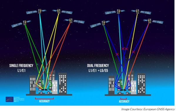
Single-frequency receivers use the L1 band. The primary limitation of this band is that it’s effected by multi-path errors. Multi-path errors are caused when a satellite signal reaches the receiver from two or more paths, one directly from the satellite and the others reflected from nearby buildings or other surfaces.
Dual-Frequency
Dual-frequency receivers use the L1 and L5 bands. The L5 band can detect unwanted reflected signals caused by multi-path errors. Receivers using the L1 and L5 bands identify these unwanted signals and ensure that they do not affect the receiver’s output information.
Dual-frequency GPS chipsets have primarily been used on smartphones and smart watches and for specific high-precision IoT use cases. The first dual-frequency smartphone was the Xiaomi Mi 8 which was launched in May 2018. Dual-frequency modules/chipsets have historically been more expensive given they require more processing power and special hardware such as antennas that are capable of tracking multiple frequencies. As the cost of dual-frequency modules/chipsets has come down, they are now been used by leading IoT companies to improve their device performance.
Triple-Frequency
Triple-frequency receivers can receive a multitude of signals from any GNSS system. Triple-frequency receivers using GPS can receive navigation signals from the L1, L2, and L5 bands.
Companies offer triple-frequency receivers/modules which can handle multiple constellations and frequencies including GPS, Galileo, BeiDou, and GLONASS. These solutions provide accuracy to the centimeter.
Given the minimal accuracy gain compared to a dual-frequency receiver, demand for triple-frequency receivers is not expected to take off until autonomous vehicles or vehicles fitted with advanced driver assistance systems begin to ship in larger quantities.
Positioning Universal’s High-Precision GPS Activities
Positioning Universal has been actively working to improve the GNSS accuracy of our devices. We already have product designs in place to move from the industry norm from 2 – 2.5 meters to 1-meter accuracy. This improved accuracy will offer our customers new capabilities such as being able to identify the specific lane a vehicle is traveling in on a highway and to locate a vehicle in a specific parking space on an auto dealer’s lot.
We are also launching products with dual-frequency modules/chipsets in Q3 2023, which coupled with new applications, will further improve our device accuracy from 1-meter to centimeters.